South Carolina: Road signs — Part 2 Practice Test
Questions in this part include: “When planning a trip, what does the manual say to use to determine your route?” · “Why are only a few of the more important secondary road numbers shown on a state primary system map?”
Independent educational site · not affiliated with any government agency or DMV
Ready? Test yourself
- Instant feedback with an explanation
- Every answer cites its source in the manual
- Your best score is saved on this device
- Keyboard: press 1 to 4 to answer and Enter for the next question
Questions are original and based on the official manual "South Carolina Driver's Manual" (2026 (posted April 2026)), South Carolina Department of Motor Vehicles.
All 21 questions in this practice test
Take the test above first, then use this list to study. Tap “Show answer” to see the correct answer and explanation.
Show the questions and answersHide the questions
-
What do speed limit signs show?
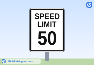
- The minimum speed you must drive in all conditions
- The maximum legal speed allowed in ideal conditions
- The speed you should drive in rain, fog, or snow
- The average speed that vehicles travel on the road
Show answer
Correct answer: The maximum legal speed allowed in ideal conditions
A speed limit sign shows the maximum legal speed allowed in ideal conditions.
Source: South Carolina Driver's Manual (2026 (posted April 2026)), page 6-10 · Open this page in the manual (Manual page 6-10)
-
Where must you stop at a stop sign when a stop line or crosswalk is present?
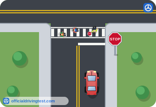
- On the stop line, with your front wheels over it
- In the crosswalk, so you can see cross traffic
- Behind the stop line or crosswalk
- Past the crosswalk, at the edge of the intersection
Show answer
Correct answer: Behind the stop line or crosswalk
At a stop sign you must stop behind the stop line or crosswalk if one is present.
Source: South Carolina Driver's Manual (2026 (posted April 2026)), page 6-10 · Open this page in the manual (Manual page 6-10)
-
At a stop sign with no stop line or crosswalk, where do you stop?
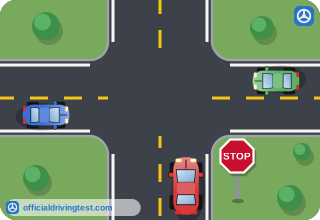
- At the point nearest the intersection where you can see both ways without entering cross traffic
- At the point where your front bumper just reaches the edge of the cross traffic lane, to get a better view
- At the point farthest from the intersection where you can still see the traffic signal ahead
- At the point where you can see in one direction, then creep forward until you can see the other
Show answer
Correct answer: At the point nearest the intersection where you can see both ways without entering cross traffic
Without a stop line, stop at the point nearest the intersection from which you can see both ways without entering the cross traffic lane.
Source: South Carolina Driver's Manual (2026 (posted April 2026)), page 6-10 · Open this page in the manual (Manual page 6-10)
-
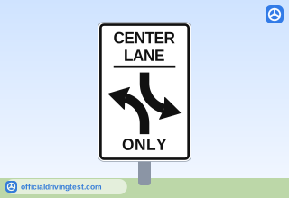
A white sign shows the words CENTER LANE ONLY with left-turn arrows pointing in both directions. What does it tell you?
- The lane is for through traffic and for passing slower vehicles
- The lane may be used only by vehicles that are turning right
- The lane is reserved for traffic traveling in one direction only
- The lane is reserved for left-turning vehicles from either direction
Show answer
Correct answer: The lane is reserved for left-turning vehicles from either direction
A Shared Center Lane Left Turn Only sign marks a lane reserved for left turns from either direction, not for through traffic or passing.
Source: South Carolina Driver's Manual (2026 (posted April 2026)), page 6-10 · Open this page in the manual (Manual page 6-10)
-
What does a one-way street sign with an arrow tell you?
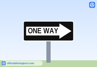
- Traffic flows only in the direction of the arrow
- Traffic flows in both directions, with the arrow showing the faster lane
- Traffic may flow against the arrow if the road is clear
- Traffic must turn in the direction of the arrow
Show answer
Correct answer: Traffic flows only in the direction of the arrow
One-way signs tell you that traffic moves only in the direction the arrow points.
Source: South Carolina Driver's Manual (2026 (posted April 2026)), page 6-10 · Open this page in the manual (Manual page 6-10)
-
On a one-way street, which turn must you not make?
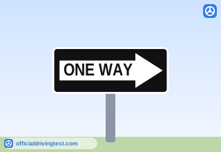
- A turn in the same direction as the arrow
- Any turn at an intersection
- A turn in the opposite direction of the arrow
- A turn onto a street with a stop sign
Show answer
Correct answer: A turn in the opposite direction of the arrow
On a one-way street you must not turn in the direction opposite the arrow, and you must never drive the wrong way.
Source: South Carolina Driver's Manual (2026 (posted April 2026)), page 6-10 · Open this page in the manual (Manual page 6-10)
-
What do guide signs do?
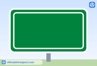
- Warn you of possible danger that might be ahead and tell you to slow down
- Tell you about specific laws that you must obey, such as parking rules
- Alert you that people are working on or near the roadway ahead
- Give information on intersecting roads and direct you to cities and towns
Show answer
Correct answer: Give information on intersecting roads and direct you to cities and towns
Guide signs give information on intersecting roads, direct you to cities and towns, and show points of interest.
Source: South Carolina Driver's Manual (2026 (posted April 2026)), page 6-11 · Open this page in the manual (Manual page 6-11)
-
Which of these can guide signs help you find?
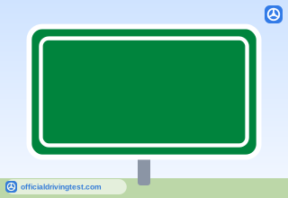
- Speed enforcement zones and police checkpoints
- Closed roads and the detour routes around them
- Hospitals, service stations, restaurants, and hotels
- Railroad crossings and the school zones near them
Show answer
Correct answer: Hospitals, service stations, restaurants, and hotels
Guide signs can help you find hospitals, service stations, restaurants, and hotels.
Source: South Carolina Driver's Manual (2026 (posted April 2026)), page 6-11 · Open this page in the manual (Manual page 6-11)
-
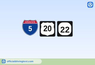
What do the shape and color of route number signs indicate?
- The speed limit on the road
- The type of roadway
- The number of lanes on the road
- The distance to the next city
Show answer
Correct answer: The type of roadway
The shape and color of a route number sign tell you whether the road is an interstate, US, state, city, county, or local road.
Source: South Carolina Driver's Manual (2026 (posted April 2026)), page 6-11 · Open this page in the manual (Manual page 6-11)
-
When planning a trip, what does the manual say to use to determine your route?
- Only the route signs along the way
- Only the guide signs at interchanges
- A road map or GPS device
- The speed limit signs on each road
Show answer
Correct answer: A road map or GPS device
The manual says to use a road map or GPS device when planning a trip.
Source: South Carolina Driver's Manual (2026 (posted April 2026)), page 6-11 · Open this page in the manual (Manual page 6-11)
-
During a trip, what does the manual say will help you avoid getting lost in an unfamiliar area?
- Following the vehicle ahead of you
- Following the route signs
- Staying on the road with the highest speed limit
- Following the brown guide signs only
Show answer
Correct answer: Following the route signs
Following the route signs during the trip helps prevent getting lost in an unfamiliar area.
Source: South Carolina Driver's Manual (2026 (posted April 2026)), page 6-11 · Open this page in the manual (Manual page 6-11)
-
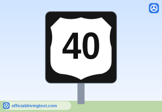
A black square sign shows a white shield-shaped panel with the number 40 in black. What type of route does it mark?
- US Route
- State Route
- Interstate Route
- Secondary System Road Marker
Show answer
Correct answer: US Route
A white shield-shaped panel with a black route number on a black square is the US Route sign.
Source: South Carolina Driver's Manual (2026 (posted April 2026)), page 6-11 · Open this page in the manual (Manual page 6-11)
-
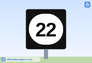
A black square sign shows a white rounded oval panel with the number 22 in black. What type of route does it mark?
- US Route
- Interstate Route
- Secondary System Road Marker
- State Route
Show answer
Correct answer: State Route
A white oval panel with a black route number on a black square is the State Route sign.
Source: South Carolina Driver's Manual (2026 (posted April 2026)), page 6-11 · Open this page in the manual (Manual page 6-11)
-
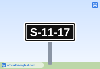
On a secondary system road marker such as S-11-17, what does the first number after the letter S stand for?
- The number of the road
- The number of the county the road is in
- The number of miles to the next town
- The number of lanes on the road
Show answer
Correct answer: The number of the county the road is in
On a secondary system marker, the first number after the S is the county number.
Source: South Carolina Driver's Manual (2026 (posted April 2026)), page 6-11 · Open this page in the manual (Manual page 6-11)
-
On a secondary system road marker such as S-11-17, what does the last number identify?
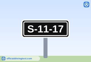
- The road number
- The county the road is in
- The speed limit in miles per hour
- The year the road was built
Show answer
Correct answer: The road number
On a secondary system marker, the last number is the road number within the county.
Source: South Carolina Driver's Manual (2026 (posted April 2026)), page 6-11 · Open this page in the manual (Manual page 6-11)
-
How are secondary road numbers set up across the state?
- One statewide set of secondary road numbers is used for all counties
- Secondary roads have no numbers
- Secondary road numbers repeat every ten miles
- There is a separate set of secondary road numbers for each county
Show answer
Correct answer: There is a separate set of secondary road numbers for each county
Each county has its own separate set of secondary road numbers.
Source: South Carolina Driver's Manual (2026 (posted April 2026)), page 6-11 · Open this page in the manual (Manual page 6-11)
-
Why are only a few of the more important secondary road numbers shown on a state primary system map?
- Secondary roads are closed to through traffic
- Secondary roads are not maintained by the state
- There are too many secondary roads to show
- Secondary road numbers change every year
Show answer
Correct answer: There are too many secondary roads to show
There are too many secondary roads to show on a state primary system map, but all of them are on county maps.
Source: South Carolina Driver's Manual (2026 (posted April 2026)), page 6-12 · Open this page in the manual (Manual page 6-12)
-
What are secondary system roads?
- Interstate highways that bypass the cities and larger towns
- Toll roads that connect each county with its neighboring counties
- Roads built only to serve traffic in cities and larger towns
- Local roads built to serve traffic in both rural and urban areas
Show answer
Correct answer: Local roads built to serve traffic in both rural and urban areas
Secondary system roads are local roads that serve traffic in both rural and urban areas.
Source: South Carolina Driver's Manual (2026 (posted April 2026)), page 6-12 · Open this page in the manual (Manual page 6-12)
-
Who should not normally use secondary system roads in rural areas, because they are not intended as through routes?
- Drivers who are carrying passengers in the car
- Drivers who are driving after dark in the area
- Drivers who are not familiar with the area
- Drivers of passenger cars in the area
Show answer
Correct answer: Drivers who are not familiar with the area
In rural areas, secondary system roads are not meant as through routes and should not normally be used by drivers unfamiliar with the area.
Source: South Carolina Driver's Manual (2026 (posted April 2026)), page 6-12 · Open this page in the manual (Manual page 6-12)
-
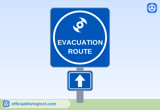
A blue square sign shows a hurricane symbol inside a white circle, with an arrow plate below it. What does it indicate?
- A storm shelter is open at the next exit along this road
- The road or highway is used as an evacuation route in a hurricane
- The road is closed to all traffic during the storm
- Drivers must turn around and leave the coast right away
Show answer
Correct answer: The road or highway is used as an evacuation route in a hurricane
A blue sign with a hurricane symbol marks a road used as an evacuation route during a hurricane.
Source: South Carolina Driver's Manual (2026 (posted April 2026)), page 6-12 · Open this page in the manual (Manual page 6-12)
-
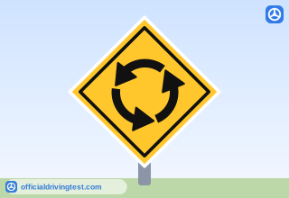
A yellow diamond-shaped sign shows black arrows forming a circle. What does it warn of?
- A divided highway beginning
- A roundabout or traffic circle
- A sharp curve in the road ahead
- Two roads merging ahead
Show answer
Correct answer: A roundabout or traffic circle
A yellow diamond sign with arrows in a circle warns drivers of a roundabout or traffic circle.
Source: South Carolina Driver's Manual (2026 (posted April 2026)), page 7-7 · Open this page in the manual (Manual page 7-7)