Missouri: Road signs — Part 3 Practice Test
Questions in this part include: “Where may lane control signs be located?” · “From which end are exit numbers numbered on an interstate that travels west and east?”
Independent educational site · not affiliated with any government agency or DMV
Ready? Test yourself
- Instant feedback with an explanation
- Every answer cites its source in the manual
- Your best score is saved on this device
Questions are original and based on the official manual "Missouri Driver Guide" (Revised August 2026), Missouri Department of Revenue.
All 16 questions in this practice test
Take the test above first, then use this list to study. Tap “Show answer” to see the correct answer and explanation.
Show the questions and answersHide the questions
-
Where may lane control signs be located?
- Along the road or hanging over the road
- Only painted on the pavement
- Only at railroad crossings
- Only at the end of interstate ramps
Show answer
Correct answer: Along the road or hanging over the road
Lane control signs are along the road or hanging over the road.
Source: Missouri Driver Guide (Revised August 2026), page 49 · Open this page in the manual (Manual page 49)
-
A white sign shows a black arrow that curves to the right past a shape on its left. What does it require?
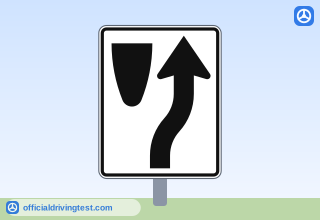
- Traffic to pass only to the left side of a feature or obstruction
- Slow vehicles to use the right lane only
- Traffic to pass only to the right side of a feature or obstruction
- Drivers to turn right at the next intersection
Show answer
Correct answer: Traffic to pass only to the right side of a feature or obstruction
A keep right sign marks locations that require traffic to pass only to the right side of a feature or obstruction.
Source: Missouri Driver Guide (Revised August 2026), page 50 · Open this page in the manual (Manual page 50)
-
What do guide signs show?
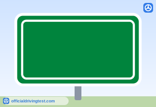
- Direction and distance to cities, airports, and state lines
- Rules for traffic direction, lane use, and turning
- The location of services such as rest areas and hospitals
- Work being performed on or alongside the roadway
Show answer
Correct answer: Direction and distance to cities, airports, and state lines
Guide signs show direction and distance to various locations such as cities, airports, and state lines, or to special areas such as national parks.
Source: Missouri Driver Guide (Revised August 2026), page 54 · Open this page in the manual (Manual page 54)
-
A blue rectangular sign has white letters or symbols. What does this kind of sign show?
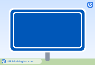
- Direction and distance to cities and airports
- Where services such as rest areas and hospitals are
- Work being performed beside the roadway
- Rules for traffic direction and lane use
Show answer
Correct answer: Where services such as rest areas and hospitals are
Service signs show the location of various services, such as rest areas and hospitals.
Source: Missouri Driver Guide (Revised August 2026), page 54 · Open this page in the manual (Manual page 54)
-
What does the shape of a route sign indicate?
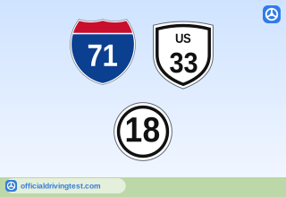
- The maximum speed limit allowed on the roadway
- The number of lanes the roadway has ahead
- The direction you are traveling on the roadway
- The type of roadway, such as interstate or state
Show answer
Correct answer: The type of roadway, such as interstate or state
The shape of route signs indicates the type of roadway: interstate, United States, state, or county.
Source: Missouri Driver Guide (Revised August 2026), page 54 · Open this page in the manual (Manual page 54)
-
What does the manual say to use when planning a trip to determine your route?
- A highway map
- Emergency reference markers
- Service signs
- Exit numbers
Show answer
Correct answer: A highway map
When planning a trip, you use a highway map to determine your route and then follow the route signs during the trip.
Source: Missouri Driver Guide (Revised August 2026), page 54 · Open this page in the manual (Manual page 54)
-
How are north-south routes identified?
- By even numbers
- By three-digit numbers only
- By odd numbers
- By numbers ending in zero
Show answer
Correct answer: By odd numbers
North-south routes are identified by odd numbers.
Source: Missouri Driver Guide (Revised August 2026), page 54 · Open this page in the manual (Manual page 54)
-
How are east-west roads identified?
- By odd numbers
- By even numbers
- By three-digit numbers only
- By numbers ending in five
Show answer
Correct answer: By even numbers
East-west roads are identified by even numbers.
Source: Missouri Driver Guide (Revised August 2026), page 54 · Open this page in the manual (Manual page 54)
-
How are interstate highways that loop around cities identified?
- Three-digit numbers that begin with an odd digit
- Two-digit numbers that are always odd
- Two-digit numbers that are always even
- Three-digit numbers that begin with an even digit
Show answer
Correct answer: Three-digit numbers that begin with an even digit
Interstate highways that loop around cities are identified by three-digit numbers which begin with an even digit, such as I-270 and I-435.
Source: Missouri Driver Guide (Revised August 2026), page 54 · Open this page in the manual (Manual page 54)
-
How are roadways called "spurs", which direct traffic into a city's road system, identified?
- Three-digit numbers that begin with an odd digit
- Three-digit numbers that begin with an even digit
- Two-digit numbers that are always odd
- Two-digit numbers that are always even
Show answer
Correct answer: Three-digit numbers that begin with an odd digit
Spurs, the roadways that direct traffic into a city's road system, are identified by three-digit numbers which begin with an odd digit, such as I-155 and I-170.
Source: Missouri Driver Guide (Revised August 2026), page 54 · Open this page in the manual (Manual page 54)
-
From which end are exit numbers numbered on an interstate that travels west and east?
- From the east, starting at zero
- From the middle of the state
- From the west, starting at zero
- From the south, starting at zero
Show answer
Correct answer: From the west, starting at zero
Interstates traveling west/east are numbered starting from the west, so exit numbers start at zero and increase as you drive east.
Source: Missouri Driver Guide (Revised August 2026), page 54 · Open this page in the manual (Manual page 54)
-
Where do exit numbers begin on an interstate that travels north and south?
- At the north point, increasing toward the south
- At the south point, increasing toward the north
- At the middle of the state, increasing both ways
- At the west point, increasing toward the east
Show answer
Correct answer: At the south point, increasing toward the north
Interstates that travel north/south have their exits numbered beginning at the south point and increasing north.
Source: Missouri Driver Guide (Revised August 2026), page 54 · Open this page in the manual (Manual page 54)
-
You enter Missouri from the north on a north-south interstate and drive south. What happens to the exit numbers?
- They increase
- They stay the same
- They start over at zero at each exit
- They decrease
Show answer
Correct answer: They decrease
If you enter the state from the north and drive south, then the exit numbers decrease.
Source: Missouri Driver Guide (Revised August 2026), page 54 · Open this page in the manual (Manual page 54)
-
Where are emergency reference markers placed?
- Along the outside shoulder
- In the median between the roadways
- Over the travel lanes
- On the center line of the road
Show answer
Correct answer: Along the outside shoulder
Emergency reference markers are mile markers placed along the outside shoulder to mark the edge of the roadway.
Source: Missouri Driver Guide (Revised August 2026), page 54 · Open this page in the manual (Manual page 54)
-
How often are emergency reference markers located along the interstate?
- Every three-tenths of a mile
- Every four-tenths of a mile
- Every two-tenths of a mile
- Every five-tenths of a mile
Show answer
Correct answer: Every two-tenths of a mile
The reference markers are located every two-tenths of a mile, so motorists will always be in sight of a sign.
Source: Missouri Driver Guide (Revised August 2026), page 54 · Open this page in the manual (Manual page 54)
-
What information do emergency reference markers give about your travel?
- The speed limit and the next exit distance
- The direction of travel and the route number
- The name of the next town and its distance
- The number of lanes ahead
Show answer
Correct answer: The direction of travel and the route number
Emergency reference markers tell the direction of travel and route number.
Source: Missouri Driver Guide (Revised August 2026), page 54 · Open this page in the manual (Manual page 54)